Forecasters warned Friday that it’s going to be a windy weekend in the Southland, as a storm system brings strong and potentially damaging velocities to much of the region beginning late Saturday through Sunday.
The high winds are expected to develop Friday night but then diminish through early Saturday before “a tremendous amount of upper-level energy” sweeps over the area, bringing high wind watches and advisories, according to the National Weather Service.
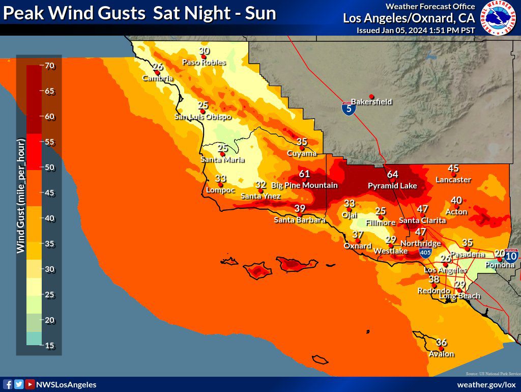
According to the weather service, the winds will first strengthen over Santa Barbara and Ventura counties late Saturday afternoon before expanding through the Los Angeles area in the overnight hours and continuing through Sunday evening.
Wind advisories will be in effect from 7 p.m. Saturday through 7 p.m. Sunday in the Los Angeles area, the San Gabriel Valley and Catalina Island, and Orange County, with velocities around 15 mph Saturday afternoon, growing to 15- 25 mph after midnight and to 30 mph Sunday night — and featuring 40-55 mph gusts.
A high-wind warning will be in effect in the L.A. County mountains and Northern Channel Islands, with gusts of 60-70 mph and isolated gusts as high as 80 mph, the weather service said.
High-wind watches will be in effect for some of the coastal valleys and foothills, as well as the Malibu Coast, where the weather service reported 60 mph gusts could occur.
The weather service cautioned Southland residents to use extra caution when driving, especially in high-profile vehicles, and to secure outdoor objects.
The storm could also produce light rain, but “any precipitation with this system should be light, except along the north slopes, including the Interstate 5 Grapevine, where a couple inches of snow could occur,” according to the NWS.
Temperatures are expected to dip into the mid-40s Friday night, reach the mid-60s Saturday, then drop into the mid-40s again on Saturday night.