Parts of Los Angeles County experienced flooding Saturday morning as a strong one-day rainstorm hit the area, creating dangerous conditions on roads and at beaches.
A flood advisory was in effect until 11 a.m. for a portion of southwest California, including central and southern Los Angeles County, and far eastern Ventura County, according to the National Weather Service.
Local law enforcement agencies reported some urban and small stream flooding in the advisory area. Some locations that were warned about possible flooding include Long Beach, Malibu, Griffith Park, Hollywood, downtown Los Angeles, Universal City, Burbank, Beverly Hills, North Hollywood, Culver City, Alhambra, Inglewood, Pasadena, Van Nuys, Venice, Santa Monica and Encino.
The NWS also issued a special weather statement for the areas of Santa Clarita, Newhall and San Fernando, where winds up to 50 mph were expected.
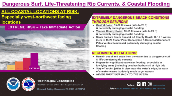
Meanwhile, a high surf warning was in effect until 10 p.m. Saturday for all Los Angeles County beaches, including the Malibu Coast and Catalina Island.
“Significant flooding of sea water is likely over vulnerable low- lying coastal areas around the time of high tide,” according to the NWS. “Damage to coastal roadways and structures is possible. Powerful waves and strong rip currents will pose an exceptional risk of ocean drowning and damage to coastal structures like piers and jetties. Large breaking waves can cause injury, wash people off beaches and rocks, and capsize small boats near shore.”
The large waves were expected to create dangerous conditions for anyone entering the water with the possibility of flooding in areas close to the beach. Forecasters warned that the county will continue to see waves of 10 to 15 feet, with some reaching as high as 20 feet, accompanied by dangerous rip currents.
The highest surf was anticipated at west-facing beaches such as Hermosa, Manhattan and Palos Verdes, forecasters said.
Due to safety concerns relating to the high surf and ocean swell, the Manhattan Beach Pier will be closed through Sunday, city officials said.
Los Angeles County health officials issued an ocean water quality rain advisory until at least 6 a.m. Tuesday, advising people to avoid all water contact, especially near discharging storm drains, creeks, and rivers due to potentially higher bacteria levels in these areas.
Long Beach issued a rain advisory and said recreational swimming areas should be avoided. City officials also urged residents and visitors to drive carefully through the area. Residents in low-lying areas such as Alamitos Bay were urged to “be vigilant and prepare for potential localized flooding due to the large swells.” Sand and sandbags were being made available to residents at city fire stations.
NWS forecasters added: “Stay off of beaches and coastal walkways, roads, and structures. Do NOT drive around barricades or through water of unknown depth. Everyone should remain out of the water due to life-threatening surf conditions. Stay off of jetties, piers, and other water side infrastructure.”
In Orange County, a high surf warning and coastal flood advisory will be in effect until 2 a.m. Monday. Forecasters said Orange County beaches will see waves of 6 to 15 feet.
According to the NWS, the Orange County locations most susceptible to flooding include Seal Beach, Sunset Beach and Newport Beach.
The high surf was the result of “powerful cyclones over the northern Pacific waters,” according to the NWS. The waves were expected to ease a bit Friday night before a another “strong wave front” arrives Saturday morning.
Conditions are expected to dry out Saturday night and Sunday morning, though very light rain is possible on New Year’s Day. Forecasters said the system will likely only produce less than a tenth of an inch of rain, meaning the Rose Parade should escape any major downfalls, although the NWS conceded the day’s forecast “is still pretty iffy.”
The area will dry out again Tuesday, with another brief storm system predicted to arrive Wednesday.
Thunderstorms to close out 2023 in parts of Inland Empire
The final weekend of 2023 may end with a bang in parts of the Inland Empire as thunderstorms move through the region, generated by back-to-back storm systems, according to the NWS.
The agency said several troughs of low pressure originating from the Gulf of Alaska will trigger the atmospheric instability.
“Showers will move in from the west as early as (Friday) night and should move to our east by early Sunday morning,” according to an NWS statement. “Current precipitation estimates are for one- to three-tenths of an inch for … valleys, with higher totals favored for northern areas. Thunderstorms could produce locally higher rainfall amounts.”
The Riverside metropolitan area could be on the receiving end of isolated thunderstorms anytime between 10 a.m. and 4 p.m. Saturday. Rainfall chances are up to 80%, the Weather Service stated.
The first trough will traverse the region Saturday and gradually exit to the east Sunday morning, followed immediately afterward by a weaker trough “that will bring another round of mostly light precipitation,” according to the NWS.
“Snow totals will be less than an inch at 6,000 feet, up to about three inches on the higher peaks of the San Bernardino Mountains,” the agency said.
Temperatures will drop with the onset of the instability, according to meteorologists.
Daytime highs in the Riverside metropolitan area Saturday will peak just below 60 degrees, with overnight lows in the mid-40s. The temperature band will be largely the same Sunday and Monday.
In the Coachella Valley, the highs Saturday and Sunday will top out in the mid 60s, and nighttime temps will be in the upper 40s. The mercury will climb back up to 70 degrees Monday, down to the upper 40s Monday night.
Rainfall chances in the desert areas are much lower.
The Temecula Valley’s temperature range will be virtually identical to the Riverside area’s for the weekend and going into early next week.
There will be a drying out regionally Tuesday, with another storm system set to arrive on Wednesday, forecasters said.
High surf, flood advisories in effect in San Diego County
High-surf, coastal flood and small craft advisories are in effect through Monday at San Diego County beaches, with sea-wave heights from 8 to 14 feet, forecasters said Saturday.
All three advisories will be in effect until at least 2 a.m. Monday and include warnings of dangerous swimming and surfing conditions, beach erosion, pier damage and likely flooding of up to 6 feet at low-lying coastal areas during the midmorning high tides.
Locations most susceptible to flooding include Cardiff and Seaside State Beaches, portions of Del Mar, La Jolla Shores, Mission Beach and Imperial Beach. Potential flooding of lots, parks and roads are possible, with only isolated road closures expected.
Officials advised that breaking waves can sweep people off jetties and docks and into dangerous seas. Inexperienced swimmers should remain out of the water, they said.
The small craft advisory covers coastal waters from San Mateo Point to the Mexican border and out to 30 nautical miles, extending 30 to 60 nautical miles to San Clemente Island, according to the NWS.
The rain was expected to end by early afternoon Saturday, with more light rain in the forecast for Wednesday.
Sunday’s San Diego surf forecast includes a high-risk rip current, with surf height from 5 to 8 feet, sets to 12 feet and an easing west swell from 270 degrees and south swell from 190 degrees.
Along the coast, partly cloudy conditions are expected through Monday, with daytime temperatures hitting the lower 60s. Inland Valley areas are expected to be partly cloudy, with highs reaching the lower to mid-60s.
The desert areas are expected to see highs in the mid-60s throughout the week, with daytime temperatures ranging from the lower to mid-50s in the mountains.
Sunday’s downtown San Diego forecast calls for a slight chance of showers after 10 a.m., with a high near 63 degrees. Forecasters called for a slight chance of showers downtown Monday, with a high near 62 degrees.