Light rain dampened the morning commute Wednesday as the leading edge of a powerful storm system began reaching the area, bringing with it concerns about potential flooding and gusty winds expected to stretch into Friday.
“A strong storm will bring many hours of steady moderate-to-heavy rain today (Wednesday) and Thursday,” according to the National Weather Service. “There will also be gusty southerly winds through Friday. The rain will bring a threat of flooding and thunderstorms.”
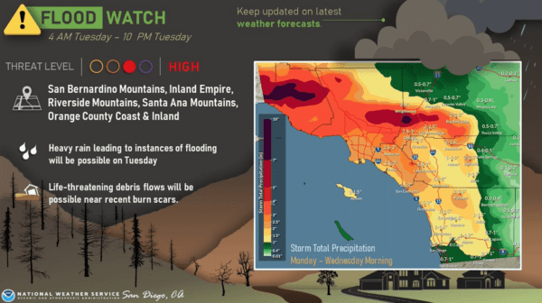
A flood watch will be in effect across Los Angeles County until late Thursday night. In Orange County, the flood watch will be in effect through Friday afternoon for coastal and inland areas and the Santa Ana Mountains and foothills.
Rain fell on much of the area Tuesday and into Wednesday morning, although the showers were scattered and generally light. As of early Tuesday morning, most of Los Angeles County had only received about a tenth of an inch of rain, according to the NWS. Light to moderate rainfall is expected to continue until about noon, when the brunt of the storm begins arriving.
Forecasters said there will be a 20% to 30% chance of thunderstorms developing Wednesday afternoon through Thursday night.
“During the prolonged period of moderate rain rainfall rates will mostly be between 0.30 to 0.60 of an inch/hour but areas under or near to (thunderstorms) as well as the Santa Ynez and Santa Monica Coastal ranges could see rainfall rates of 1 inch per hour,” according to the NWS. “A flood watch is in effect for the entire area through early morning Friday. There are many possible flooding hazards posed by this storm. Flash flooding, debris flows, general flooding and to a lesser extent river flooding are all possible over the next 48 hours and everyone should be alert for warnings.”
Forecasters estimated that much of the Los Angeles area could receive 2 to 4 inches of rain during the “atmospheric river” event, with 4 to 8 inches possible on south-facing foothill areas and coastal slopes.
“Extensive roadway flooding, especially in low-lying areas, and flooding of creeks and streams are possible,” according to the NWS. “In addition, there will be the risk for flash flooding and debris flows in recent burn scars, especially the South Fire burn scar in Ventura County. Also, there will be the strong potential for rock and mudslide activity, especially on canyon and mountain roadways. Flooding and rock/mudslide activity may lead to significant travel delays and road closures. Increased flow in rivers and streams will bring an increased threat for swiftwater rescues.”
Los Angeles County Lifeguards warned people to exercise caution if they visit the beach.
“Ocean conditions will also have a bit more activity with waves in the head to overhead range,” lifeguards warned on social media. “Plenty of varying factors these next few days, so make sure to stay tuned, and if you decide to come to the beach make it a point to check in with a lifeguard tower prior to entering the water.”
County health officials issued their standard warning for people to avoid entering the ocean water in the days following rain, noting that runoff can carry bacteria and debris into the ocean, raising the risk of illness.
Snow levels are expected to remain above 7,500 feet, with several inches possible at elevations over 8,000 feet.
Los Angeles County officials said various agencies were coordinating to ensure public safety while also hoping to capture as much stormwater as possible for future use.
“L.A. County owns a world class system of water conservation and flood protection. This system is prepared to capture and conserve valuable stormwater while protecting communities,” LA County Public Works Director Mark Pestrella said in a statement. “Our system is primed to capture as much stormwater as possible in our efforts to increase the region’s overall local water supply by 600,000-acre feet by 2045.”
County officials urged residents to heed instructions from emergency responders and alert notifications; drive cautiously and slow down in wet conditions; and avoid trying to cross flooded roadways.
Daytime temperatures will remain in the 60s in the region for much of the week. Overnight lows will generally be in the upper 40s and lower 50s throughout the Southland, but will dip into the 30s in some parts of the mountains and high desert.
Thursday is the first day of winter. Conditions are expected to dry out on Friday, although gusting northwest winds are expected to linger into Saturday.