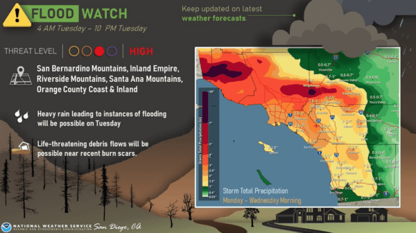
Rainstorms this week throughout the Inland Empire will produce occasionally heavy downpours, prompting the National Weather Service to issue a flood watch that will be in effect until Friday.
“Moisture will be abundant through this week,” the NWS said in a statement. “The beginning of the heavier rain will … likely begin late Wednesday night and early Thursday in Riverside and San Diego counties. Most of the heavier precipitation will be convective due to the instability of the low pressure. Hourly rainfall rates of 1 inch appear in some of the (models) for Thursday night.”
The flood watch runs from until 4 p.m. Friday.
Forecasters said two troughs of low pressure will slide through California, with the current one exiting to the east Wednesday, and the next one reaching the coast as an occluded front soon afterward, moving slowly across the region, gradually pushing into Arizona by Saturday.
The NWS predicted isolated thunderstorms, with the highest probability on Thursday.
“Snow levels will generally be above 7,000 feet through Friday but start to drop after that as moisture decreases, possibly to 6,000 feet Saturday,” the NWS stated. “The highest roads and ski resorts will encounter accumulating snowfall, with Big Bear mostly receiving rain. Winds generally will not be an issue with this storm, but some gusts over 30 mph could occur in the mountains and deserts around Thursday.”
The official start of winter is Thursday.
Temperatures will remain average throughout the storm series, with no influence from the Polar jet stream, according to meteorologists.
In the Riverside metropolitan area, highs Tuesday to Friday will be in the mid-60s, with overnight temperatures in the low 50s.
In the Coachella Valley, the daytime mercury will hover around 70 and fall into the mid-50s overnight this week, while in the Temecula Valley, the temperature band will be virtually identical to Riverside metro Tuesday to Thursday, though the daytime high will peak in the upper 50s on Friday.