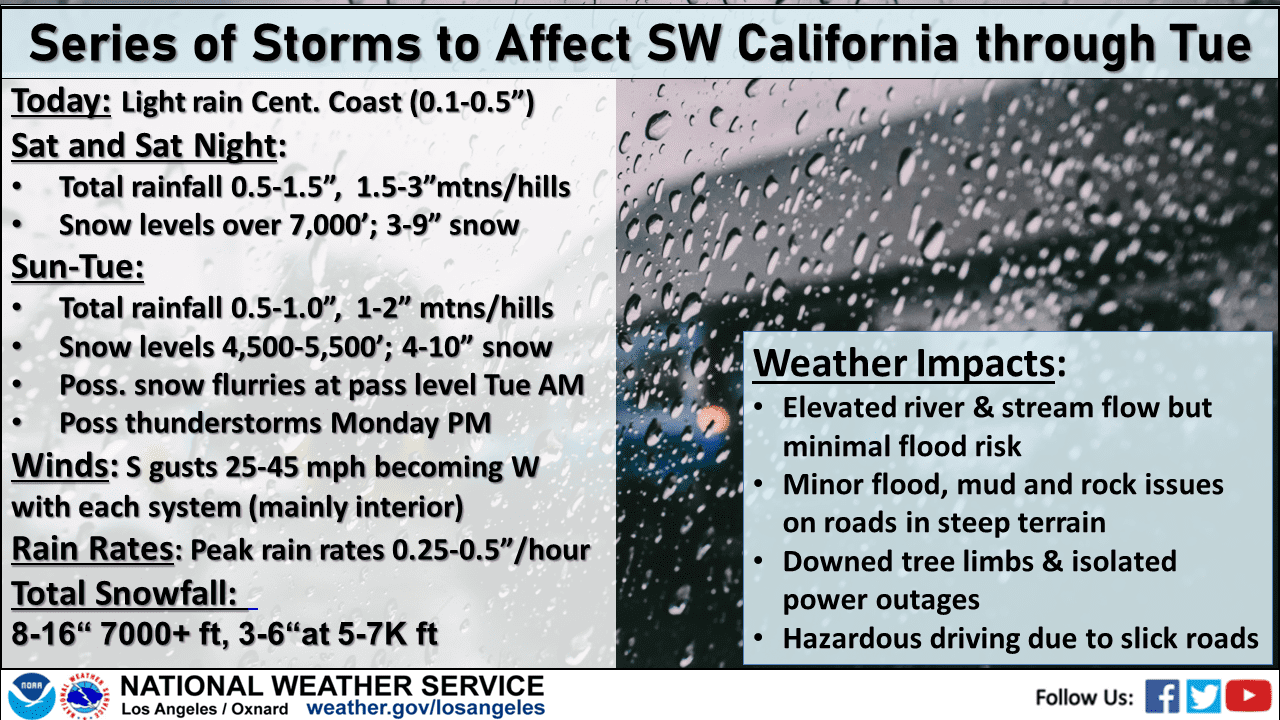
The already saturated Southland will have to endure more rain over the coming days, with forecasters anticipating off-and-on precipitation possibly beginning late Friday evening and continuing through Monday.
The National Weather Service downgraded earlier predictions of rain over the Los Angeles area Friday night, but said some “light sprinkles or very light showers” are possible.
A stronger front is expected to arrive Saturday, with the brunt of the system likely reaching Los Angeles County by late afternoon or evening.
“It’s during this period when rain rates will be at their highest,” forecasters said.
Rain will likely fall in much of the area at a rate of about a half- inch per hour.
“With these rates, impacts will be slightly greater than what would normally occur with a storm of this magnitude since the ground is still fairly saturated from previous rain, but still just on the minor side, including small mudslides in the foothills and mountains and typical minor road flooding,” according to the NWS.
Forecasters called for about an inch of rain in coastal and valley areas, and between 1.5 and 3 inches in the foothills and mountains. Snow levels will be at or above 7,000 feet, according to the NWS.
The precipitation should taper off Saturday night, and the area should get a break from the rain until late afternoon Sunday, when another less- powerful storm moves in. That system is expected to linger over the area into Monday.
Conditions should dry out by Tuesday, beginning a mostly rain-free week, but some Santa Ana winds could develop by later in the week.
A wind advisory will be in effect from noon to midnight Saturday in the Antelope Valley, with forecasters anticipating winds of 20 to 30 mph, with gusts up to 50 mph.
A winter weather advisory will be in effect from noon Saturday until 3 a.m. Tuesday for the Los Angeles County Mountains. Forecasters said as much as 3 inches of snow could fall below 7,000 feet, with 5 to 10 inches possible at higher elevations Saturday night. For Sunday night through Monday, snow could accumulate 5 to 10 inches above 5,500 feet, and 3 to 6 inches at higher points.
“Travel could be very difficult,” according to the NWS. “Gusty winds could bring down tree branches. There is a 10 to 20 percent chance of light snow accumulations on the Grapevine over Interstate 5 Monday night.”
A flood watch will be in effect in Orange County coastal and inland areas Saturday evening through late Saturday night.
Additional rain is bad news for crews that are still working to clean up after this week’s storms. A number of highway closures were still in place Friday due to mudslides or other damage, and a sinkhole that developed on a Calabasas roadway and swallowed two vehicles continued growing in size.
That sinkhole on Iverson Road was estimated on Friday to have grown to about 45 feet deep while spanning the entire roadway. The Los Angeles City Council on Tuesday approved $500,000 in emergency funding on Tuesday to expedite repairs of the sinkhole.
Another $450,000 was approved for storm repairs to Mulholland Drive between Summit Circle and Bowmont Drive.
Los Angeles Mayor Karen Bass on Friday declared a local state of emergency due to the recent storms and impending additional rain.
As of Friday, Caltrans was reporting the following closures:
- Two right lanes are blocked on the northbound Golden State (5) Freeway near Templin Highway in northern Los Angeles County by a 250-foot-long mudslide.
- The southbound 5 Freeway connector to the southbound Harbor (110) Freeway is closed due to mud and debris.
- The southbound 5 Freeway connector to the southbound 5 Freeway in the Boyle Heights area is closed due to a mudslide.
- Both directions of SR 2 in the Angeles National Forest are closed from 3.3 miles east of Newcomb’s Ranch to SR 39 due to hazardous road conditions. Also, SR 2 is closed for the winter east of SR 39 to Grassy Hollow Campground.
Due to the new storm systems, Santa Anita Racetrack canceled all scheduled races on Saturday and Monday. Los Alamitos Race Course scrubbed all races planned for Saturday night.