Cooler temperatures are on the way to the Southland this week, along with some rain, forecasters said Tuesday.
Light showers and drizzle began falling early Monday morning, with wind and a 40% chance of rain in the forecast.
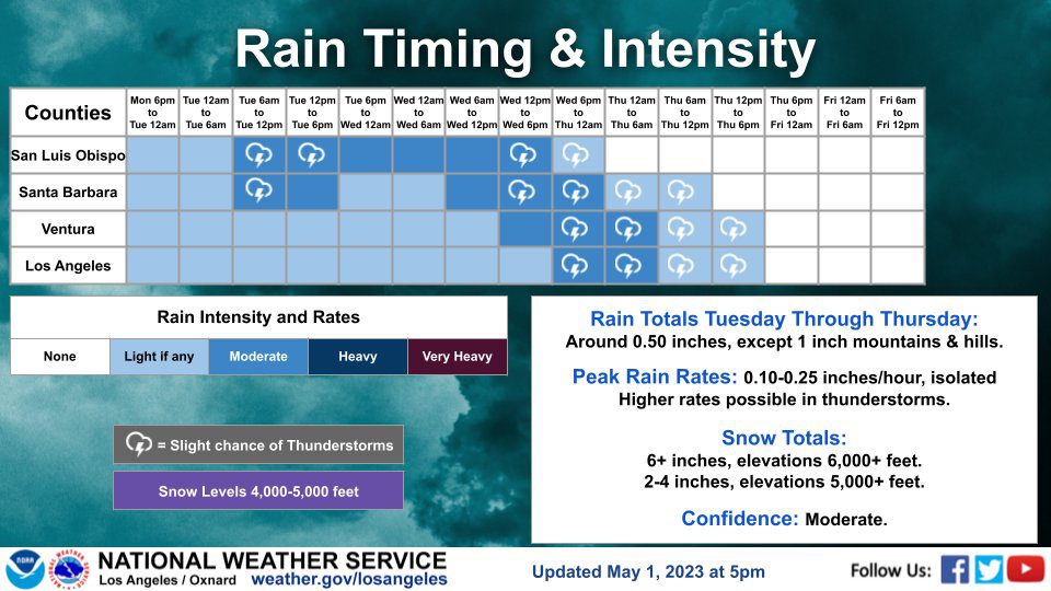
An unseasonably cold storm system will move over the region through Thursday, bringing rain and mountain snow, gusty winds and slight chance of thunderstorms, according to the National Weather Service.
Drizzle and light rain was forecast for Los Angeles and Orange counties Monday night and Tuesday morning, with the potential for heavier rainfall Tuesday through Thursday, especially Thursday.
“We are still looking at a big change in the weather this week, with a storm system bringing rain & mountain snow Tue-Thu,” the NWS’ Los Angeles office tweeted Sunday afternoon, adding a third to an inch of rain and between 4 and 8 inches of snow above 5,000 feet are expected.
The weather service also reported a slight chance of thunderstorms Wednesday and Thursday.
Sunday’s high of about 70 degrees in downtown Los Angeles was expected to drop to 59 on Tuesday, with highs of 62 forecast Wednesday and Thursday. Highs were expected to linger in the low 60s in much of Los Angeles and Orange County through at least Thursday.
The NWS predicted a “good chance of a warming and drying trend for late week.”