Light to moderate rain fell across most of the Southland Wednesday as residents braced for the brunt of the “bomb cyclone” moving across the state, with forecasters saying the full force of the storm should hit Los Angeles County early Thursday morning.
“A strong Pacific storm system will affect the area through Thursday with strong winds, damaging surf, heavy rain with flooding and high elevation snow,” according to the National Weather Service.
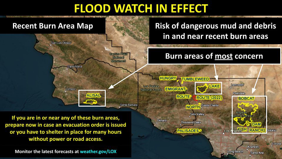
Forecasters said light rain and gusty winds will continue into Wednesday night — the front end of an “atmospheric river” storm that promises to drop several inches of rain in a short period of time, raising the risk of flooding and debris flows in recent burn areas.
The main plume of the storm is expected to push into Los Angeles County around 4 a.m. Thursday, according to the NWS, which said most areas will receive “around six hours of steady moderate to heavy rain.” Most areas will receive a total of 2 to 4 inches of rain, forecasters said, while the mountains and foothills could get 4 to 8 inches — with isolated spots possibly seeing 10 inches of precipitation.
Rain rates will peak at 0.5 to 1 inch per hour, although “isolated rates” of 1.25 inches per hour are possible.
“These type of rain intensities and amounts will create flooding problems,” according to the NWS. “This is a lot of water and the threat of flooding is a real concern. Expect a lot of roadway flooding, including a few freeway closures. The Thursday morning commute will be bad. Several small streams will likely flood and spill over. Stay out of and away from any creeks and drainages as these could become deadly quickly.”
The NWS issued a flood watch that will be in effect from 10 a.m. Wednesday through Thursday afternoon over the bulk of the Southland and in Orange County.
A high surf advisory will be in effect from 6 a.m. Thursday to 10 a.m. Friday.
A winter storm warning will be in effect from 6 p.m. Wednesday to 10 p.m. Thursday for the Los Angeles County Mountains including the cities of Acton and Mount Wilson.
Forecasters said 1 to 2 feet of snow could accumulate at elevations above 7,000 feet, with 4 to 8 inches possible above 6,000. Mountain winds could also gust up to 60 mph, according to the NWS.
The wintry weather could lead to “slippery road conditions” on some of the higher roadways in the mountains, such as Angeles Crest and Big Pines highways in Los Angeles County, forecasters warned.
The rain will be accompanied by gusting winds in the Southland. Wind advisories will be in effect for the bulk of the area from 6 p.m. Wednesday until 10 a.m. Thursday, with winds of 15 to 25 mph expected, along with gusts of up to 40 mph. Winds could hit 50 mph in the Antelope Valley, according to the NWS. In Orange County, a wind advisory will be in effect from 2 a.m. to noon Thursday, with winds of 15 to 25 mph possible, including gusts of up to 40 mph, according to the NWS.
“There will be many potential problems associated with this storm system including urban and small stream flooding, rocks and debris on roads, downed trees and numerous power outages, and mud and debris flows out of recent burn areas,” according to the NWS.
The dire storm predictions have led to ramped-up preparations across the Southland.
At 8 a.m. Wednesday, the Los Angeles Department of Transportation closed Laurel Canyon Boulevard between Hollywood Boulevard and Mulholland Drive, a move that was taken “in preparation for heavy rain.” The closure remained in place until about 11 a.m., allowing crews “to secure roads in advance of inclement weather,” according to the LADOT.
Crews installed concrete k-rail barriers in the area to help control anticipated storm runoff.
Meanwhile, Caltrans officials cautioned motorists statewide to stay off the roads if possible.
“Caltrans districts statewide are coordinating with local & state officials to assist with this latest storm system. TRAVEL IS NOT RECOMMENDED,” the agency tweeted Tuesday.
Caltrans officials also said they cleared a section of the Angeles Crest (2) Highway in the Angeles National Forest below state Route 39, but drivers were advised to check Quickmap.dot.ca.gov for chain requirements.
In Duarte, city officials declared a Yellow Alert for about two dozen homes near the Fish Fire burn area, imposing restrictions to keep cars and trash bins off streets that could potentially flood.
Many cities also handed out sandbags to residents to help them protect their properties from potential flooding and mud flows.
Gov. Gavin Newsom, meanwhile, declared a state of emergency across California to expedite anticipated damage repair. The state also pre-positioned fire and rescue crews across the state to quickly respond to flooding or other emergencies.
The state urged residents to be prepared for the storm, and anticipate power outages by having flashlights and batteries on hand.
The NWS warned that “many power outages are nearly certain, and could be prolonged by the concurrent heavy rain. Plan ahead now for what you would do if the power was out for several hours.”
Conditions are expected to dry out by Thursday night, continuing into Friday. A series of “weak disturbances” are anticipated over the weekend, but “there will likely be drier and less cloudy intervals in between the clouds and rain,” forecasters said.
Temperatures, meanwhile, will remain about six degrees cooler than normal through the weekend.
With rain falling, Los Angeles County health officials issued their standard warning for people to avoid entering ocean water near discharging storm drains, creeks and rivers. An ocean water quality rain advisory will be in effect until at least 7 a.m. Friday.
Health officials noted that stormwater runoff that reaches the ocean can carry bacteria, chemicals, debris trash and other health hazards. People who come in contact with impacted water in the ocean could become ill, health officials said.
More rain was in the forecast early next week, with a chance of showers Sunday through Tuesday, according to the NWS.