Yet another storm is set to douse the already saturated Southland with rain by early next week, and while the system won’t pack the same punch as the area’s recent record-setting downpours, flood fears are being heightened due to the region’s soaked terrain.
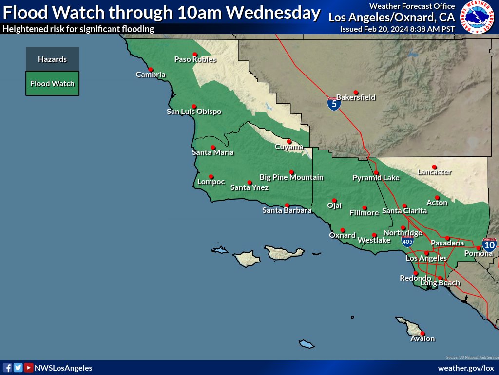
The National Weather Service has issued a flood watch that will be in effect for most of the Los Angeles area from Sunday afternoon through Wednesday morning, warning that “excessive runoff” is still possible that could overwhelm rivers, streams and other flood-prone locations.
“Area creeks and streams are running high and could flood with more heavy rain,” forecasters noted.
The region is expected to remain mostly dry into Saturday, with the front of the storm system pushing into the area by Saturday night. But the Los Angeles area is only expected to receive at most a tenth-of-an-inch of rain, if any.
The stronger portion of the storm is expected in the area Sunday night into Monday, bringing a “weak atmospheric river” over the basin. Rain is expected to be generally light in the LA area Monday morning, but increasing as the day and week wears on. Forecasters said that by Tuesday evening, “heavier showers will be likely, and thunderstorms cannot be ruled out.”
“Any thunderstorm is capable of briefly producing damaging wind gusts and a weak tornado, eve if there is little to no lightning,” according to the NWS. “Rainfall totals during this time will generally be 0.5 to 1 inch, with up to 2 inches possible across south-facing slopes and especially the eastern San Gabriel Mountains. Rainfall rates will approach up to 1 inch per hour during times of convection and the heaviest showers.”
Rainfall predictions over the entire duration of the storm, which is expected to continue until Wednesday, but forecasters said the “most likely scenario” calls for totals of 2 to 4 inches in coastal and valley areas, and 4 to 6 inches possible in foothills and mountains, with some localized totals reaching up to 8 inches.
Inland Empire
The next storm system rolling toward the Inland Empire won’t have quite the same intensity as the last round of inclement weather, with mostly showery activity and light rainfall totals in the forecast, though the mountains could be in store for more snow, according to the National Weather Service.
“The movement of this system will be slow,” the agency said in a statement. “Areas east of Interstate 15 and south of Interstate 10 in the Inland Empire, as well as the coast to the mountains in San Diego County, are likely to see near one-third to three-fourths of an inch of rain in total, with minimal accumulations across the lower deserts.”
Several low pressure troughs are trundling toward Southern California from the northwest Pacific Ocean, and the leading edge of the instability will probably cause light rain to develop Sunday night or in the predawn hours Monday. The most intense downpours will likely be offshore or to the north, forecasters said.
“The possibility for this system to stall some before moving inland looks to be coming to fruition,” the NWS stated. “The system may even stall enough to see minimal rainfall … during the day on Monday.”
Prognostication charts published by the Weather Service showed the troughs brushing up against a ridge of high pressure rotating through the middle of California Monday and Tuesday.
The “atmospheric rivers” that generated heavy precipitation throughout the inland region earlier this month are not active this time around, according to meteorologists.
No flood or winter weather advisories had been issued as of Friday afternoon.
The NWS said snow levels will generally hold above 7,000 feet Sunday and Monday. However, Tuesday night into Wednesday, frozen precipitation can be expected down around 6,000 feet.
“Confidence is increasing that areas like Wrightwood and Big Bear will see locally one to two inches of snowfall,” the Weather Service said. “Upper level winds will also be strong as this system pushes through … with gusts 25 to 40 mph at times for mountains and deserts Monday through Wednesday.”
The adverse weather will break up and clear to the east by Wednesday evening, followed by a dayslong dry spell.
In the Riverside metropolitan area, daytime temperatures for the weekend will reach the upper 60s, with nighttime lows in the upper 40s. Monday to Wednesday, the highs will top out in the low 60s, and lows around 50.
In the Coachella Valley, the weekend highs will hover in the mid-70s, falling to the low 50s at night. Monday to Wednesday, temps will peak at 70, with lows in the low 50s.
For the Temecula Valley, weekend highs will reach the mid-60s, and lows in the mid-40s, while Monday to Wednesday, the temperature band will be virtually identical to Riverside metro.