Yet another powerful storm pounded the Southland Tuesday, with rain and mountain snow expected to continue throughout Wednesday, raising the risk of localized flooding.
A winter storm warning was in effect until 11 p.m. Wednesday in the San Gabriel Mountains and in the 5 and 14 Freeway corridors. Forecasters predicted total accumulations of 2 to 5 feet of snow above 6,000 feet during the storm, with 10-20 inches possible between 5,000 and 6,000 feet, and 2-10 inches between 3,500 and 5,000 feet — accompanied by winds gusting to 75 mph. According to the National Weather Service, several inches of snow could fall in the Grapevine section of the Golden State (5) Freeway.
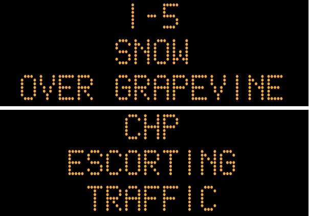
“Snow is starting to stick on I-5 in the Lebec area. CHP started running escorts,” Caltrans tweeted at 5:43 p.m. Tuesday. “Maintenance crews have been on duty 24/7 since last night & are plowing to maintain public safety.”
Caltrans later said the escorts stopped at about 7:30 p.m. but the freeway was still wet, and motorists were urged to drive carefully and reduce speeds.
A wind advisory was in effect until 11 p.m. Tuesday for most of Los Angeles County.
Shortly after 8 p.m., the NWS issued a brief tornado warning for southwestern Los Angeles County and central Ventura County. At 8:17 p.m., “a severe thunderstorm capable of producing a tornado was located over Point Mugu State Park, or 10 miles south of Camarillo, moving northeast at 35 mph,” according to the agency.
The warning expired at about 8:30 p.m. Forecasters said the storm that prompted the warning had weakened below severe limits, and no longer appeared capable of producing a tornado.
Rain soaked most of the Southland Tuesday morning, but the skies cleared by early afternoon, even bathing the region in sunshine for a few hours. But by late afternoon, another wave of the storm moved in, darkening skies just in time for the afternoon rush hour.
Forecasters warned that it would be “a very active night,” with showers and isolated thunderstorms spreading into Los Angeles County, bring periods of heavy rain.
“Showers (will) continue into Wednesday as the upper low moves just north of the area,” according to the NWS. “Showers will become more scattered but still briefly heavy at times. Air mass isn’t quite as unstable but can’t rule out a thunderstorm or two in L.A. County in the morning hours. Snow levels expected to remain around the 4,000 (foot) level.”
Up to 3 inches of rain could fall in coastal and valley areas by the time the storm subsides Wednesday, with foothill and mountain areas seeing 3-6 inches, according to the NWS.
Maximum temperatures will fall into the 50s on Wednesday, about 10 to 15 degrees below normal.
The rain is expected to persist in the region through Wednesday, with some showers potentially even lingering into Thursday, but otherwise, the region should be cool and dry through the weekend.
A flood watch will also be in effect for Orange County coastal and inland areas through Wednesday evening — with rivers, creeks, streams and other low-lying and flood-prone locations susceptible.