Snow, rain and hail fell across the Southland Friday as a winter storm with an intensity not seen in decades slammed the region, leading to flooded streets and a closure of the Grapevine that made driving a generally miserable experience across the area.
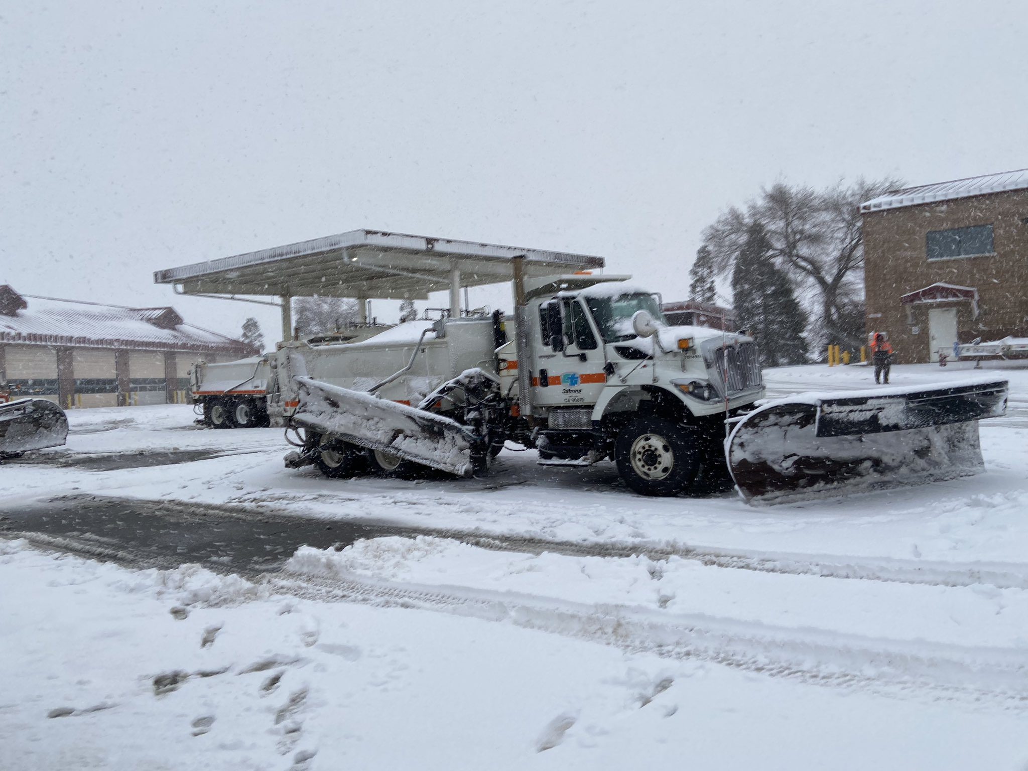
Heavy snow in the northern reaches of Los Angeles County prompted an early morning closure of the Grapevine section of the Golden State (5) Freeway. The northbound roadway was closed at Parker Road in Castaic, and the southbound lanes were closed at Grapevine Road.
There was no indication of when the stretch would be reopened, frustrating motorists in the much-traveled corridor.
A blizzard warning — the first issued in the area since 1989 — took effect early Friday morning in the Los Angeles County mountains, and it will remain in place until 4 p.m. Saturday.
National Weather Service forecasters said up to 5 feet of snow could accumulate in the mountains above 4,500 feet, accompanied by wind gusts topping 80 mph that will create “near zero visibility.” Higher elevations could see as much as 8 feet of snow, with accumulations of 6 to 12 inches possible at elevations between 2,000 and 4,500 feet, impacting major mountain passes.
“Travel could be very difficult to impossible,” according to the National Weather Service. “Potential for road closures. Some mountain roadways may be impassable for an extended period of time. Very strong winds could cause extensive tree damage.
“Travel should be restricted to emergencies only,” according to the NWS. “If you must travel, have a winter survival kit with you. If you get stranded, stay with your vehicle.”
The Antelope Valley will be under a winter weather advisory until 10 p.m. Friday, with 3 to 6 inches of snow expected in the foothills and 1 to 3 inches on the valley floor, along with winds gusting to 45 mph, forecasters said.
A flash flood warning was issued for the entire county, remaining in place until 10 p.m. Friday, although forecasters pointed to Burbank, Griffith Park, Universal City, North Hollywood, Pasadena, Hollywood, downtown, Van Nuys, Beverly Hills, Alhambra, Mount Wilson, Encino, Northridge, Santa Clarita, Chatsworth, Woodland Hills, Whittier, West Covina, Glendora and San Dimas as areas that are likely to experience flash flooding.
“Flash flooding will be limited to locations below snow levels, which will fall from 5,000 feet to 3,500 feet (Friday night),” according to the NWS. “Flash flooding is expected to worsen into the evening hours.”
Forecasters noted that by early afternoon Friday, flooding had already been occurring in areas of Burbank and the San Fernando Valley, with the Southland being doused with rain totals ranging from 1 to 5 inches.
According to the NWS, rainfall rates could reach one inch per hour in parts of Los Angeles County by Friday evening, mainly in the foothills and mountains. But valley and coastal areas were also likely to get bouts of heavy rain.
Forecasters also said thunderstorms could sporadically develop, generating “dangerous cloud-to-ground lightning,” along with “gusty and erratic winds” and small hail.
The snow level is expected to slowly rise as the day wears on, reaching between 4,000 and 6,000 feet. But cold air could keep that level lower in the Antelope Valley and other far northern areas of the county.
The main front of the storm is expected to move out of the area Friday evening, but “showers will likely continue across the region into Saturday,” according to the NWS. “The potential for isolated thunderstorms will linger into Saturday afternoon.”
Forecasters said that even when the precipitation begins to dissipate, a cold air mass will keep temperatures “much below normal through the weekend.”
Record low temperatures were reported in parts of Orange County Thursday. It was 57 in Anaheim on Thursday, breaking the record for the lowest maximum temperature of 58 set in 2022. It was 54 in Newport Beach, breaking the record of 55 set in 1946.
Rain and hail fell on parts of Los Angeles and Orange counties Thursday. Even the Hollywood Sign was hit by hail, along with Venice Beach. Pasadena, Santa Monica and Long Beach also got pelted with hail.
Coastal and valley areas could get between 2 and 5 inches of rain during the storm by Saturday night, with 5 to 10 inches possible in the foothills.
In Duarte, city officials implemented a yellow alert in the Fish Fire burn area beginning at 11 a.m. Thursday. During the alert, Mel Canyon Road will remain closed between Brookridge and Fish Canyon roads, and residents of the 25 homes in the area will be under parking restrictions and ordered to remove trash bins from the street. The trash pickup scheduled for Friday was canceled and rescheduled for Monday, city officials said.
Temperatures will be in the 40s and 50s in most of the area, although they will drop into the 30s in the mountains and some valley areas, particularly at night, and into the 20s in the Antelope Valley.
High winds will make it feel even colder. Forecasters said strong winds will impact the entire region Friday and Friday night, strongest in the mountains and deserts. Gusts of 55 to 75 mph are anticipated in those areas, contributing to the blizzard-like conditions.
“Winds may drop off Saturday, so the blizzard warning may be downgraded early for some areas,” forecasters said. “Expect whiteout conditions at times within the blizzard warning, mainly above 3,500 to 4,500 feet in elevation. Significant blowing and drifting of snow combined with the whiteout conditions will make driving very difficult to impossible, including for rescue crews.
“The incredible amount of snow combined with the strong wind will lead to extreme avalanche conditions along steeper terrain and at lower elevations than we typically experience in southern California. The most significant threat for avalanches is typically within 24 hours of new snowfall. The heavy snowfall will increase risk of downed trees and power outages and can cause damage to roofs which have shallow slopes.”
The bad weather forced a series of closures and cancellations of events across the area. The Major League Soccer season-opening match Saturday at the Rose Bowl between the LA Galaxy and LAFC was postponed to an undetermined date. A BikeLA Cruise & Connect ride scheduled for Saturday through Griffith Park was also scrubbed.
Horse racing has been canceled through the weekend at Santa Anita Park in Arcadia. Knott’s Berry Farm and Six Flags Magic Mountain were both closed Friday.