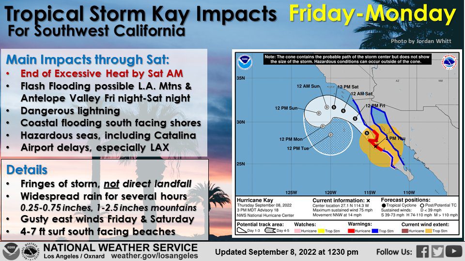
Southern California entered the 10th and possibly final day of a prolonged heat wave Friday, with Tropical Storm Kay off the coast bringing clouds and rain into the forecast and raising fears of possible flooding in mountain areas.
The National Weather Service issued a flood watch that will be in effect from 11 p.m. Friday through Saturday evening in the Los Angeles County Mountains and Antelope Valley.
“Moisture from Kay will move into the area today (Friday) and linger through Saturday,” according to the NWS. “Showers and thunderstorms with periods of heavy rain at times will increase the risk of flooding, especially in the mountains. The heaviest rain is expected to occur late tonight through Saturday evening.”
Forecasters said the rain could lead to excessive runoff resulting in “flooding of rivers, creeks, streams and other low-lying and flood-prone locations.”
Kay had been categorized as a hurricane, but it weakened as it made landfall Thursday night, then began shifting to the northwest over the ocean. But Kay was still packing a punch, promising to bring widespread rain across the region.
The cloud cover from the storm was helping to trap warm air in the region, meaning continued hot weather on Friday, despite some overcast conditions, along with increased humidity. Excessive heat warnings will remain in effect for most of the Southland until 8 p.m. Friday. Then the rain will move in.
“Rainfall amounts should generally range between a quarter to half inch for the coast, a third to two-thirds of an inch for the valleys, and a half to one-and-one-half for the mountains,” according to the NWS. “For the Antelope Valley, generally a third to two-thirds of an inch is expected for the storm. Locally higher amounts could develop, especially with any thunderstorms. Heavy downpours are possible across the mountains and desert where terrain will cause orographic effects that could increase rainfall rates.”
The storm has already caused higher tides, prompting concerns of localized flooding along the coast. In Long Beach, crews worked overnight to fortify berms, and sandbags were being made available to residents to help protect their properties from flooding.
Long Beach fire and parks officials were focusing efforts in Alamitos Beach, building up protective berms mainly between Fifth and Ninth places.
“High tide for Long Beach will be at 9:16 p.m. tonight,” the Long Beach Fire Department noted on its Twitter page. “Please take efforts now to prepare your homes if you live in vulnerable locations along our coastline that are prone to flooding.”
The NWS warned that Kay will bring steep seas and gusty east winds to coastal waters through Saturday.
Gale force winds are expected at Catalina and San Nicolas Islands, with a chance of winds reaching 20 to 30 knots north to Point Conception and the Channel Islands.
Los Angeles County Supervisor Janice Hahn said sandbags were being made available to Catalina residents on the east side of South Beach. She noted that the story “is forecasted to bring wind, high surf and coastal flooding to the island.”
According to Hahn, Catalina Express canceled the 5:45 p.m. departure from San Pedro to Avalon, as well as the 7:40 p.m. boat from Avalon to San Pedro and the 9:45 p.m. departure from Avalon to Long Beach.
In the meantime, high heat will persist Friday, bringing with it concerns about strain on the statewide power grid. The California Independent System Operator, which manages the grid, issued another Flex Alert for 4 to 9 p.m. Friday, urging residents to cut back their power use to avoid strain on the system and possible rolling blackouts.
The alerts have been in place nightly throughout the heat wave, and thus far they have worked — with Cal-ISO avoiding any calls for rolling power outages.
During the Flex Alert, residents are asked to save power by:
- setting thermostats to 78 degrees or higher;
- avoiding use of major appliances;
- turning off unnecessary lights; and
- avoid charging electric vehicles.
Residents were also advised to pre-cool their homes as much as possible and close blinds and drapes to keep interiors cool.
The power grid has been pushed to the limit during the heat wave. Late Tuesday afternoon, statewide electricity demand reached 52,061 megawatts, breaking the record of 50,270 MW set in 2006, according to Cal-ISO.
Southern California has seen temperatures soar above 100 degrees every day since Wednesday of last week. Los Angeles International Airport reached 97 degrees on Thursday, breaking the record for the date of 93 degrees, set in 1984.
It was 103 in Anaheim on Thursday, breaking a record of 102 set in 2015. It was 95 in Newport Beach, breaking a record of 90 set in 1984.
Excessive heat warnings will be in effect through 8 p.m. Friday for the inland coastal area including downtown Los Angeles, the Santa Monica Mountains, L.A. County beaches, the Malibu coast and the San Gabriel, San Fernando and Santa Clarita valleys. The warnings expired at 8 p.m. Thursday in the Los Angeles County mountains and Antelope Valley.
The excessive heat warning will also be in place until 8 p.m. Friday for Orange County coastal and inland areas, including valleys in San Bernardino and Riverside, and the Santa Ana mountains and foothills.
“Drink plenty of fluids, stay in an air-conditioned room, stay out of the sun, and check up on relatives and neighbors,” the NWS urged. “Young children and pets should never be left unattended in vehicles under any circumstances.”
Forecasters also urged residents to be aware of the signs of heat stroke and to take precautions.
Cooling centers for Los Angeles County can be found at ready.lacounty.gov/heat/. Cooling centers for Los Angeles can be found at emergency.lacity.org/la-responds/beat-heat, or by calling 311.