The first significant deluge of heavy rain during the fall season prompted evacuation orders Tuesday in Pacific Palisades and warnings in the Eaton Fire burn area amid the heightened threat of mudslides, floods and thunderstorms.
The deadly Palisades and Eaton fires devastated Los Angeles County communities in January, leaving terrain especially vulnerable to heavy rainfall.
Showers were expected throughout Tuesday afternoon, according to the National Weather Service.
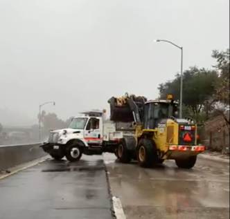
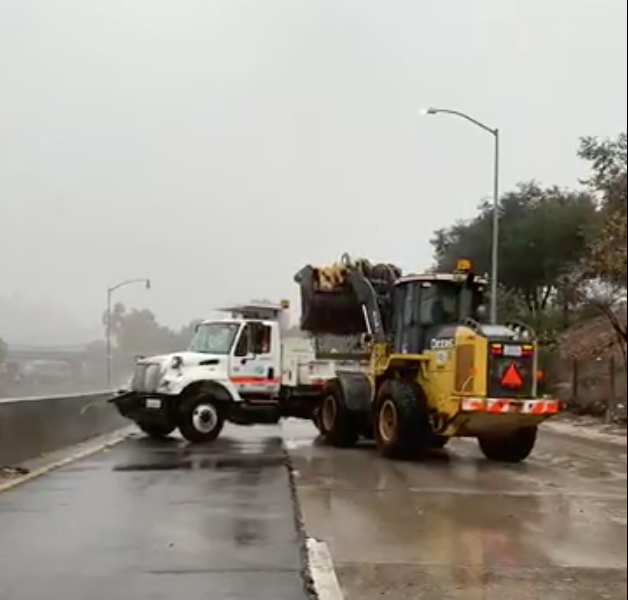
Driving on area freeways during morning hours was hazardous, with numerous spin-outs and collisions reported.
About 120 homes in Pacific Palisades were subject to mandatory evacuation orders, according to the Los Angeles Fire Department — 114 homes in the Mandeville Canyon area, five in the Hurst Fire area and one in the Sunset Fire area, the LAFD reported.
All were deemed to be at higher risk from possible debris flows and Los Angeles police began knocking on doors of those homes Monday night, according to the Fire Department.
The storm was expected to drop 0.75 to 1.5 inches of precipitation across most areas, with 2 to 4 inches possible on south- facing mountain slopes, forecasters said. As much as 5 inches could fall in the San Gabriel Mountains.
Hail, wind gusts, waterspouts and a weak tornado were possible, the agency added. In line with the storms forecast peak durning Tuesday afternoon, a wind advisory remains in effect until 2 p.m. in the San Gabriel Mountains with gusts possibly reaching 50 mph. The storm system is also expected to bring gusty south to southwest winds across LA County mountains and the Antelope Valley foothills.
“Rain rate forecasts will likely be increased, especially for any south- and southwest-facing slopes,” according to the NWS. “Nearly every high-resolution model is showing streaks of heavy rain moving through the region, and while not every area will see them, these narrow bands could happen anywhere. Several of the projections are now showing the rain the organizing and intensifying as it swings into LA County, which is concerning for the recent burn scars — especially the Eaton and Bridge scars.”
Evacuation warnings were posted Monday for most recent burn scar areas, including the Palisades and Eaton fires, along with the Hurst Fire in Sylmar and the Sunset Fire in the Hollywood Hills. Residents were urged to prepare to leave amid concerns about possible flooding and debris flows.
“As today’s storm intensifies, I cannot emphasize strongly enough the importance of heeding evacuation warnings and orders,” LA County Board of Supervisors Chair Kathryn Barger, whose district includes the Eaton Fire burn scar, said in a statement. “These alerts are issued to protect lives. Conditions can change quickly, and once debris flows begin, it may be too late for emergency crews to reach you.”
Nearly 400 properties, many of which are standing homes in high-risk burn areas, could fall under mandatory evacuation orders, county officials said.
“I know that asking residents to leave their homes is disruptive and difficult,” Barger added. “But I would rather see people temporarily relocated than anyone put in harm’s way. Please, if you are in an evacuation warning zone, prepare now and be ready to leave immediately once an order is issued.”
Malibu officials announced evacuation warnings and shelter-in-place advisories for city residents in Rambla Pacifico, Carbon Beach West/Malibu Beach, Sweetwater Canyon, Sweetwater Mesa, Serra Retreat. Malibu Creek, Cross Creek, Malibu Colony, the Civic Center, Malibu Knolls, Malibu Road, Malibu Country Estates, Puerco Canyon, Las Flores Mesa, Big Rock, Big Rock Beach, Tuna Canyon south, Las Tunas Beach and Topanga Beach Drive.
The shelter-in-place advisories will remain until at least Wednesday evening for the Franklin Fire burn scar near Pepperdine University due to possible flash floods, mudslides and debris flows, city officials said.
“While this may be a short-duration storm, even a burst of intense rain can quickly create dangerous conditions in burn areas,” LA County Public Works Director Mark Pestrella said in a statement. “Our crews are ready, and we urge residents to make personal safety their top priority. Avoid driving on mountain roads or in burn areas, if at all possible, and keep trash cans and vehicles off streets to allow storm runoff to travel freely.”
Los Angeles Mayor Karen Bass said city crews were preparing in advance for heavy rain and possible flooding.
“The city has bolstered the hillsides and vulnerable areas from potential debris flows in recent burn scar areas — these resources remain in place,” Bass said in a statement. “Today, we have strategically deployed resources for the Palisades and across the city, including strike teams, rescue teams and helicopters. Be cautious on the roads, pick up free sandbags if needed and sign up for emergency alerts at NotifyLA.org. To all Angelenos: stay safe, stay informed and follow official evacuation guidance.”
Orange County officials issued an evacuation warning Monday for areas near the Airport Fire burn scar — Trabuco Creek, Hot Springs Canyon, Bell Canyon, Long Canyon and Modjeska Canyon. Authorities urged people to voluntarily evacuate the area, “especially those with disabilities, access and/or functional needs, and canyon residents with large animals.”
On Tuesday, mandatory evacuation orders took effect at 10 a.m. for Trabuco Creek including the RC Airport, fire station, campground/park and school; Bell Canyon including Starr Ranch; and Hot Springs Canyon including Lazy-W Ranch. Evacuation warnings remained in place for Long Canyon and Modjeska Canyon.
OC Animal Care, 1630 Victory Road in Tustin, was accepting dogs, cats and other small animals for people facing evacuation orders. A large animal shelter was available at the Orange County Fair Grounds, 88 Fair Drive in Costa Mesa.
Officials also closed O’Neill Regional Park because of the storm.
The NWS advised the public to take precautions, stay indoors as much as possible and avoid parking vehicles near tall trees that could be uprooted.
A flood watch was in effect Monday night lasting through Tuesday evening for recent fire-impacted areas in LA, Ventura, Santa Barbara and San Luis Obispo counties. Forecasters said the storm has could cause “hazardous and damaging flooding and debris flows.”
The NWS warned mariners of hazardous conditions for a wide area of outer waters from Santa Cruz Island off Ventura County, south to San Clemente Island off Orange County. Winds of 50 mph and steep waves up to 60 nautical miles offshore were possible, and forecasters advised boaters to seek safe harbor and take protective actions.
Temperatures fell significantly Tuesday, with highs expected in the low 60s in most areas of LA and OC. By Wednesday night, the rain will have left the region, but cooler temperatures were expected to continue until Thursday. A trend of warmer weather with highs in the 70s to low 80s was forecast for the end of the week.