
Local residents were encouraged to review and give feedback on the state’s updated Fire Hazard Severity Zone map, San Bernardino County officials announced last week.
In compliance with state law, the updated map from the California Fire Marshal’s Office categorizes areas into three wildfire risk levels — moderate, high and very high.
The previous Fire Hazard Severity Zone map was last updated from 2008-11 and identified only very high-risk zones in areas served by local fire departments. The new map’s three hazard levels aim to help the public gain a clearer understanding of wildfire threats.
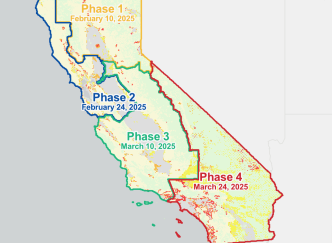
Numerous very high- and high-risk areas were identified in hillside areas in the Inland Empire, according to its March 24 update.
Ratings of fire hazard severity are based on several factors, including the likelihood of fire ignition, possible fire behavior in extreme weather conditions, historical fire incidents, types of flammable vegetation, terrain features such as hills and canyons, proximity to wilderness areas and anticipated weather patterns over the next 50 years. The hazard ratings also take into account “flame and ember intrusion from nearby wildlands and flammable vegetation within urban areas, offering a more localized evaluation of wildfire risk,” according to a county statement.
While local governments don’t have the authority to lower fire hazard risk ratings assigned at the state level, city, county and tribal officials may choose to increase ratings if local conditions warrant the change.
Fire hazard ratings guide key safety regulations, including state “wildland urban interface” building codes, officials said. New buildings constructed in high- and very high-risk zones are subject to more stringent safety regulations. Property owners also must maintain a buffer space by clearing vegetation to reduce the risk of wildfires damaging structures.
The public comment period for the new fire-risk map concludes April 30. The county will hold public hearings and ordinance readings before the formal adoption of the Fire Hazard Severity Zone map by the Board of Supervisors on June 10.
For more information about the fire hazard map and to submit a comment, go to sbcfire.org/fire-hazard-severity-zone-map.