Severe weather earlier this month due to remnants of Tropical Storm Mario, brought heavy rains, flooding and mudslides to mountain and desert communities, prompting a coordinated response from San Bernardino County departments.
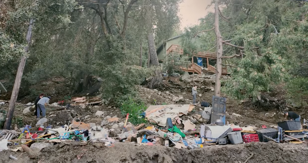
A powerful storm Sept. 18 triggered mud and debris flows throughout the El Dorado Fire burn scar in the San Bernardino National Forest, impacting the Oak Glen, Forest Falls, Glass, Seven Oaks and Potato Canyon areas. The debris flows moved across the Yucaipa Ridge area, destroying portions of the ridge and sending mud and debris rushing into the communities below.
The storm also caused severe washouts on Highway 38, damaging sections that officials expect to remain closed for months.
Rainfall in the desert region also drew flood warnings in Twentynine Palms, Landers, Barstow and Trona.
As the storm set in, the county Office of Emergency Services established an operations center to guide a coordinated response. The county fire department, Cal Fire personnel, the county sheriff’s department along with Emergency Services staff were part of the unified command, supported by the county Public Works Department and state agencies Caltrans and the Governor’s Office of Emergency Services.
“Once again, our first responders and county departments came together quickly to protect lives, restore access, and support residents in difficult circumstances,” Dawn Rowe, San Bernardino County Board of Supervisors chairman and 3rd District supervisor, said in a statement. “To the families and businesses affected, we stand with you and will continue to advocate for the assistance you need. We thank the public for heeding safety warnings while crews work to restore normalcy to the affected communities.”
Rescue and safety operations
As the storm struck, motorists stranded along Highway 38 were rescued by Caltrans, officials said. Firefighters from the county’s Harrison Canyon hand crew shoveled mud and debris from residences in Forest Falls.
In Oak Glen, mud and debris blocked multiple roads and creek crossings, according to the county. Residents sheltered in place as safety patrols provided support and Public Works personnel “worked around the clock” to remove debris and restore access to the area for residents and emergency responders.
Cleanup and recovery
In Forest Falls, slides and blocked roads were reported from Canyon Drive through Slide Creek and Holy Pines, officials said.
“Along Highway 38, significant washouts — including one near Hawthorne Creek estimated at 50 feet deep and a quarter mile wide — were documented, with additional washouts near South Fork and North Fork Park under evaluation by Caltrans,” according to a county statement.
Public Works road and flood crews are operating extended shifts, with loaders, dump trucks, graders and contract support clearing roads and flood channels, officials said Friday. Valley of the Falls Drive has reopened at an “emergency width,” and Potato Canyon has been cleared to a single lane. Closures will remain in place until work is completed.
A total of 19 pieces of heavy equipment have removed over 1,770 cubic yards from the Oak Glen Channel and 3,100 cubic yards from Birch Creek Channel, officials reported. Road Operations workers have removed 1,600 cubic yards of sediment and debris from roadways.
Forest Falls has eight pieces of heavy equipment and two ground crew members clearing debris and working to restore access, officials said Friday. Road Operations has removed 2,000 cubic yards of sediments and debris from roads in Forest Falls.
The Glass and Seven Oaks areas saw Road Operations remove 5,000 cubic yards of sediments and debris from roadways.
Updates on road closures are available at dpw.sbcounty.gov/operations/road-closures.
More rain was possible Friday and Saturday, with a chance for new storms as early as Sunday from Tropical Storm Narda off the coast of southern Mexico. County officials warned residents to be prepared for rapidly changing conditions.
To stay safe, residents were urged to:
- “Heed evacuation warnings and orders: Leave immediately if instructed. Debris flows and flash floods can happen suddenly, with little warning. Have a family communication plan in place.
- “‘Turn Around, Don’t Drown’: Never attempt to drive or walk through floodwaters. Just six inches of moving water can sweep a person off their feet, and deeper flows can carry vehicles away.
- “Know what to do if flooding occurs: If indoors, stay inside. If outdoors, seek higher ground immediately and avoid flood channels and flowing water,” the county advised.
The San Bernardino County Telephone Emergency Notification System sends emergency alerts to residents’ phones.
The National Weather Service – San Diego office has timely updates and warnings.
For additional information including road closures, safety alerts and recovery progress is online at Prepare.SBCounty.gov.
The California Department of Insurance provided resources for residents impacted by the mudslides via nsurance.ca.gov or a public assistance hotline available in every language, 800-927-4357.
To mitigate future mud and debris flows in federal land in the San Bernardino National Forest from impacting local communities, officials said the county will continue to seek a “strong partnership” with federal agencies and the U.S. Forest Service.