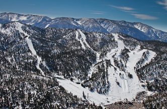

A winter weather warning was in effect Wednesday for mountain communities in Riverside and San Bernardino counties.
The winter weather warning will be in effect from 7 p.m. Wednesday until 10 a.m. Friday with heavy snow between 2 and 4 inches expected at elevations above 5,000 feet, and 4 to 8 inches above 6,000 feet in Riverside County. Wind gusts were expected to be as high as 60 mph in mountain areas.
In San Bernardino County, the forecast was for heavy snowfall of 4 to 8 inches from 5,000 to 6,000 feet, 8 to 12 inches from 6,000 to 7,500 feet, and 12 to 16 inches above 7,500 feet. Winds could gust as high as 60 mph creating a risk of tree damage, according to the National Weather Service
Travel could be very difficult and hazardous conditions could impact commutes on Thursday, forecasters said.
“If you must travel, keep an extra flashlight, food, and water in your vehicle in case of an emergency,” the NWS advised. “The latest road conditions for the state you are calling from can be obtained by calling 511.”
An “atmospheric river” will drop down from the Pacific Northwest and flow across Southern California beginning Wednesday night, lingering into Friday morning, according to the NWS.
“There are some differences in the depth and timing of the main trough (of low pressure) Wednesday into Thursday,” forecasters said in a statement. “In general, there is a 60-75% chance of at least 0.5 inches of rain for the coasts and valleys. For the high deserts, there is a 20-45% chance of at least 0.25 inches. Snow levels will be upwards of 7,000 feet at the onset of precipitation Wednesday evening, quickly falling to around 4,500 feet by Thursday morning and as low as 3,500 feet on Friday morning.”
Interstate 15 through the Cajon Pass may be impacted by the wintry weather Thursday night into Friday, according to the NWS.
“There is also some indication that an isolated thunderstorm or two could develop as cold air aloft moves into the area and vorticity moves through the main flow … both Wednesday evening and Thursday,” the NWS reported.
Thunderstorm cells materialized in the Riverside metropolitan area Sunday night as the weekend’s storm activity subsided.
After the upcoming storm system moves out of the region Friday, a dome of high pressure will deliver clear and warmer conditions for this weekend, but forecasters said more precipitation could arrive early next week.