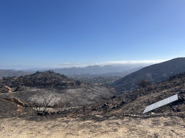
Firefighters achieved 65% containment Saturday of the Bridge Fire, the state’s largest active blaze that has been holding steady at 54,795 burned acres the last four days.
The massive wildfire began in San Gabriel Canyon near Glendora and moved swiftly into San Bernardino County and the Sheep Mountain Wilderness of the San Gabriel Mountains National Monument.
The Bridge Fire has destroyed 81 residential, commercial and other buildings, damaged 19 and was threatening 4,409 structures, according to Cal Fire.
No deaths and five unspecified injuries to firefighters were reported.
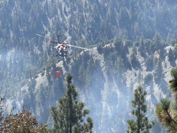
“Today, firefighters will continue mop-up efforts across the fire, securing containment lines, extinguishing isolated heat sources, and felling hazardous trees to improve public and crew safety,” Cal Fire reported in a Saturday morning statement. “Crews on the west flank will focus on constructing indirect line from Rattlesnake Peak north and Mount Baden Powell south — tying in containment lines at Mount Hawkins. On the south flank, aircraft dropping fire retardant will work with ground crews on the remaining open portion of containment line to get that area buttoned up.”
Fire officials asked residents in and around Wrightwood who are returning to fire-impacted areas to return any fire equipment found on their properties to San Bernardino County Fire Station 14, 5980 Elm St. in Wrightwood. Residents should not take firefighting equipment to Wrightwood Elementary School, officials said.
Warmer, drier weather was expected along with corresponding increased fire risk.
“The area will see a warming and drying trend as a high-pressure system from the Pacific Ocean moves in,” according to Cal Fire. “The marine layer will dissipate by early to mid-week, and relative humidities will drop, leading to elevated fire danger. Then warmer, drier weather is expected to last through the end of the month.”
Nearly 1,910 personnel were fighting the fire Saturday.
The Bridge Fire started in the afternoon of Sept. 8 near East Fork and Glendora Mountain roads, the U.S. Forest Service reported. Aided by an extended heat wave, the blaze increased Sept. 10 from 4,100 to 49,008 acres and spread from Los Angeles County into San Bernardino County. By early Sept. 13 the fire was 51,884 acres with 3% containment, according to Cal Fire.
On Sept. 14, the fire grew to 52,960 acres with containment still at just 3%, and on Monday officials reported the fire’s size at 54,690 with 11% containment. Tuesday the burned area increased slightly to 54,795 acres with containment jumping to 25%, then 35% by early Wednesday. The fire remained at 54,795 Saturday, but containment increased to 65%.
The initial report assessed the blaze at 75 acres, but it swelled to 820 acres by 7 a.m. Sept. 9 with 0% containment as a result of high winds and low humidity. By noon that day, the fire had increased to 1,255 acres with containment still at 0%.
Road closures remained in effect at the following locations:
- Big Pines Highway
- Big Rock Creek Road
- Largo Vista Road
- Mescal Creek Road
- Panorama Motorway
- SR-39 at the Base of San Gabriel Canyon — accessible only to residents of Camp Williams and River Community
- Glendora Mountain Road north of Big Dalton Road
- SR-2 at Flume Canyon Road westbound
The evacuation warning for Baldy Village, from the dam north to the ski resort and San Antonio Canyon to the east, was lifted Friday, the Los Angeles County Sheriff’s Department reported. The evacuation warning for Wrightwood has also been lifted while Bear Canyon remains under an evacuation warning.
Evacuation orders remained in place for wilderness areas near the fire zone.
An evacuation shelter for residents is at the San Bernardino County Fairgrounds, 14800 Seventh St., Building 6 in Victorville.
Small-animal shelters:
- Lancaster Animal Care Center
5210 W. Ave I in Lancaster - Palmdale Animal Care Center
38550 Sierra Highway in Lancaster
Large-animal shelters:
- San Bernardino County Fairgrounds
14800 Seventh St. in Victorville, 909-386-9820, after hours 800-472-5609 - Devore Animal Shelter accepting both small and large animals
19777 Shelter Way in San Bernardino
Gov. Gavin Newsom secured funding from the Federal Emergency Management Agency for fighting all the fires in California, including the Airport Fire, the Line Fire and the Bridge Fire in the Southland.
The LA County Board of Supervisors on Tuesday approved an emergency declaration in response to the fire. Local emergency status speeds up funding to the county from state and federal sources. Board Chair Lindsey Horvath initially issued the declaration last week.
On Sept. 12, the San Bernardino County Board of Supervisors approved an emergency proclamation in response to the fires.
The fire’s cause was under investigation.
Damage inspection teams released interactive maps for residents affected by the fire. For San Bernardino County see https://prepare.sbcounty.gov/bridge-fire/External Link; for LA County visit https://recovery.lacounty.gov/bridgefire/External Link.