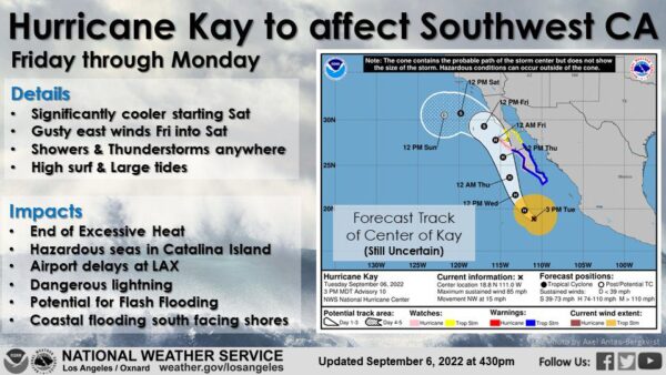
After more than a week of searing heat and dry weather, the Southland could be in store for some rain by this weekend, thanks to Hurricane Kay making its way up the Baja California coast.
The actual impact of the storm is still a little uncertain, because it’s unclear how much Kay will weaken as it moves north. But National Weather Service forecasters said the storm will bring clouds and chances of showers and thunderstorms in some areas.
Latest models predict the storm system may not move as far north as earlier predicted, but forecasters said Los Angeles County is still likely to see some rain.
The impact of Kay could be felt locally as early as Friday, according to the NWS, which noted that the storm will begin to push some cloud cover across the region. Absent those clouds, Friday was predicted to be the hottest of the next three days, “and it still might be even with the cloud cover,” according to the NWS.
Excessive heat warnings will be in place in most of the Southland through Friday, with some possibly extending into Saturday morning, forecasters said.
Saturday is expected to start off warm, but depending on Kay’s advance, temperatures should “level off quickly and possibly cool some during the day as showers develop,” according to the NWS.
The amount of rain that will fall remains a mystery, but the NWS predicted “measurable precipitation” in the area.
“Widespread light to moderate rain is likely Saturday and maybe Sunday, mainly over Los Angeles and Ventura counties,” forecasters said. “Isolated thunderstorms are also expected, especially in the mountains, which could produce heavy rain and flash flooding.”

