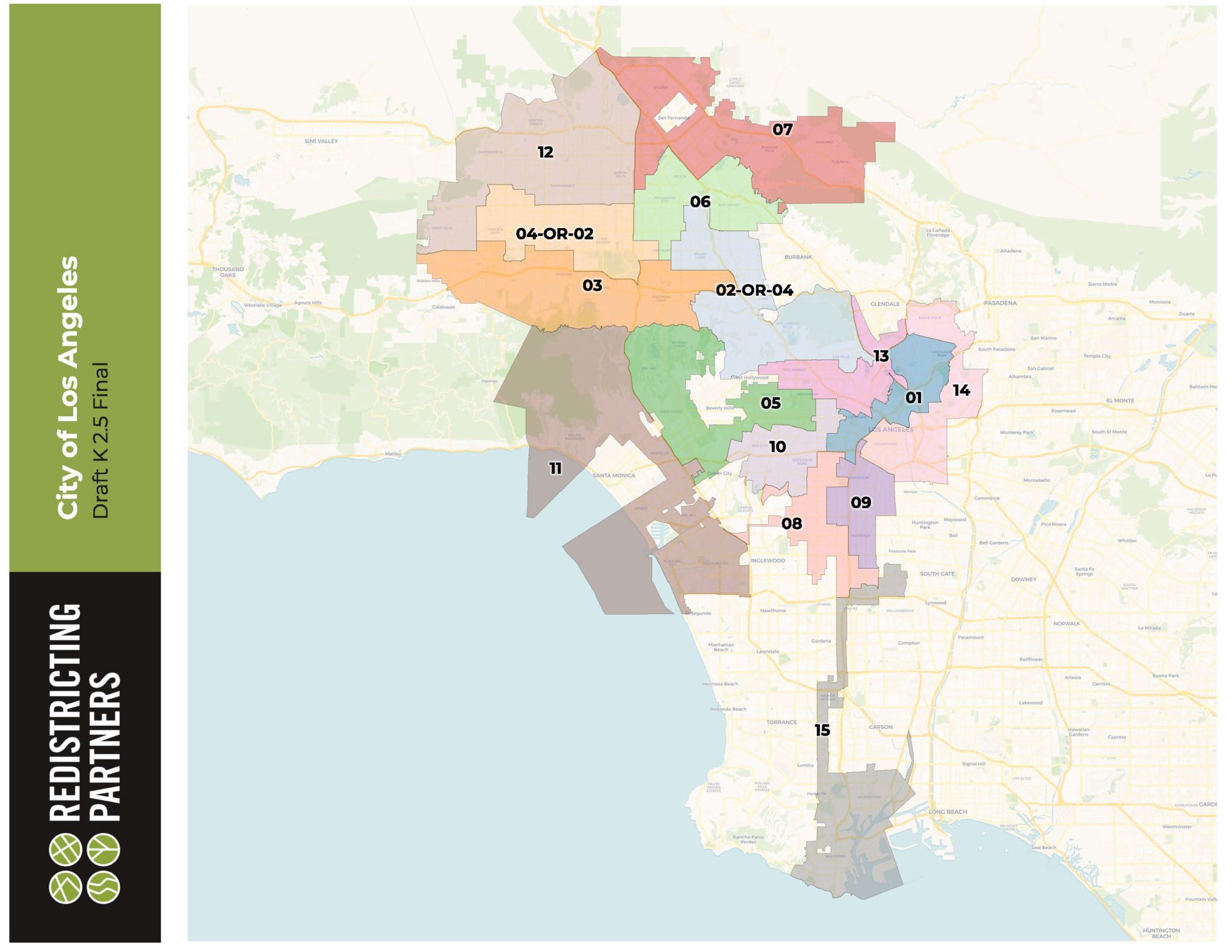
A year-long process to draft a new map of Los Angeles’ 15 council districts using 2020 census data reached the City Council Tuesday, with council members introducing a collective 38 motions to transform the draft map.
The City Council also voted 14-0 to create the Ad Hoc Redistricting Commission to lead its effort to make adjustments to the map. Council President Nury Martinez has previously criticized the draft map from the Redistricting Commission for creating drastic changes that have “confused and alienated thousands.”
Commission Chair Fred Ali called the draft “a product of unprecedented public participation, which involved more Angelenos than ever before.”
He said 15,000 people offered comment during the process, and noted challenges during the process, including the COVID-19 pandemic, census data being delayed by five months and a “historic undercount of certain communities” within that data.
Councilman Paul Krekorian, who is facing the possibility of representing an entirely new district, spoke the most during the council meeting, asking Ali and commission Executive Director Frank Cardenas about their process.
Ali and Cardenas said some of the commission’s priorities were to unify Koreatown in a single council district, have five full districts situated in the San Fernando Valley — which has about 30% of the city’s residents — and use borders already used by neighborhood councils.
“I would just conclude on this point that there may be great things in this process for the rest of the city, but this one thing of creating these two districts that the commission couldn’t even decide who should represent, is alone enough to revisit the entire drawing of the maps in the San Fernando Valley,” Krekorian said.
On Oct. 21, the commission voted to finalize its recommendations for a draft map of revised council district boundaries, but did not designate which district would be District 2 and which would be District 4. Under the recommendations, one of them would end up with entirely new constituents, called Council District 4-or-2 in the west San Fernando Valley, while the other would have Council District 2-or-4, which includes parts of both their districts — the Hollywood Hills, North Hollywood, Valley Glen and part of Los Feliz.
“The voters of the fourth district and the voters of the second district did select candidates of their choice a year ago, and the result of these maps would be to take those choices away from those voters,” Krekorian said.
Councilwoman Nithya Raman represents parts of Silver Lake, Los Feliz, Hollywood Hills, Hancock Park and Sherman Oaks, among other neighborhoods. Krekorian represents East San Fernando Valley neighborhoods, including North Hollywood, Studio City and Sun Valley.
Krekorian introduced a series of motions to move parts of other draft districts into the Council District 4-or-2 and Council District 2-or-4 designations, including Sun Valley communities of Glen Crest Hills, the Van Nuys neighborhoods of Katherine Circle and Katherine Square, as well as the area bounded by Roscoe Boulevard, Whitsett Avenue, the railroad track and Laurel Canyon Boulevard.
He and Raman also motioned to move out of Council District 4-or-2 and into Council District 3 the areas of Winnetka, Canoga Park and Woodland Hills, and in return Sherman Oaks would move to Council District 4-or-2 from Council District 3. Krekorian also sought to have Valley Village moved from Council District 3 to Council District 2-or-4.
Councilman Mitch O’Farrell introduced a motion, which was seconded by Raman, to move the boundary between Council District 2-or-4 and Council District 13 in the Atwater Village Area from the Golden State (5) Freeway to the center of the Los Angeles River.
Councilman Curren Price introduced a motion to change his district’s recommended borders, including to move Exposition Park from Councilman Marqueece Harris-Dawson’s Council District 8 to his district Council District 9, which currently holds that neighborhood.
Harris-Dawson also introduced a motion, this one to move from Price’s district to his district the area bounded by West Adams boulevard, Ellendale Place, West 29th Street, Vermont Avenue, Exposition Boulevard, the Harbor Freeway, Jefferson and Hoover Street.
Other motions to adjust borders recommended by the commission were introduced by council members Gil Cedillo, Mike Bonin, Martinez, Monica Rodriguez, Bob Blumenfield and Kevin de Leon.
While council members seek to redraw their districts, there have also been calls, including by the Redistricting Commission itself, for the redistricting process to be handled by a completely independent body.
“This commission’s over the last year confirmed that the quasi- independent nature of the advisory commission simply does not work,” Ali said. “It’s time for an independent, rather than advisory, commission to assume responsibility for redistricting for the good of our city.”
The commission also called for the number of council districts to be expanded to “better create council district boundaries that reflect the city’s 99 neighborhood councils and 114 neighborhoods.”
Ali said this would have helped serve the community of Watts, which sought to be moved from Council District 15 to Council District 9. The Watts Neighborhood Council says Watts is “unnaturally linked to and also shares little in common with the other neighborhoods in the district,” which include San Pedro, Harbor City, Harbor Gateway and Wilmington.
Ali said the commission wanted to move Watts, but residents also wanted the neighborhood to remain unified, and it “proved impossible” to move a neighborhood so large into another district without shifting other neighborhoods out.
The Redistricting Commission uses data from the U.S. Census to update the city’s districts, with each Council member getting about 260,000 people to represent. The council will have the chance to make changes to the map before adopting final borders for the 15 districts to go into effect on Jan. 1.

